It’s Raining on the “Wrong” Rock

8th June

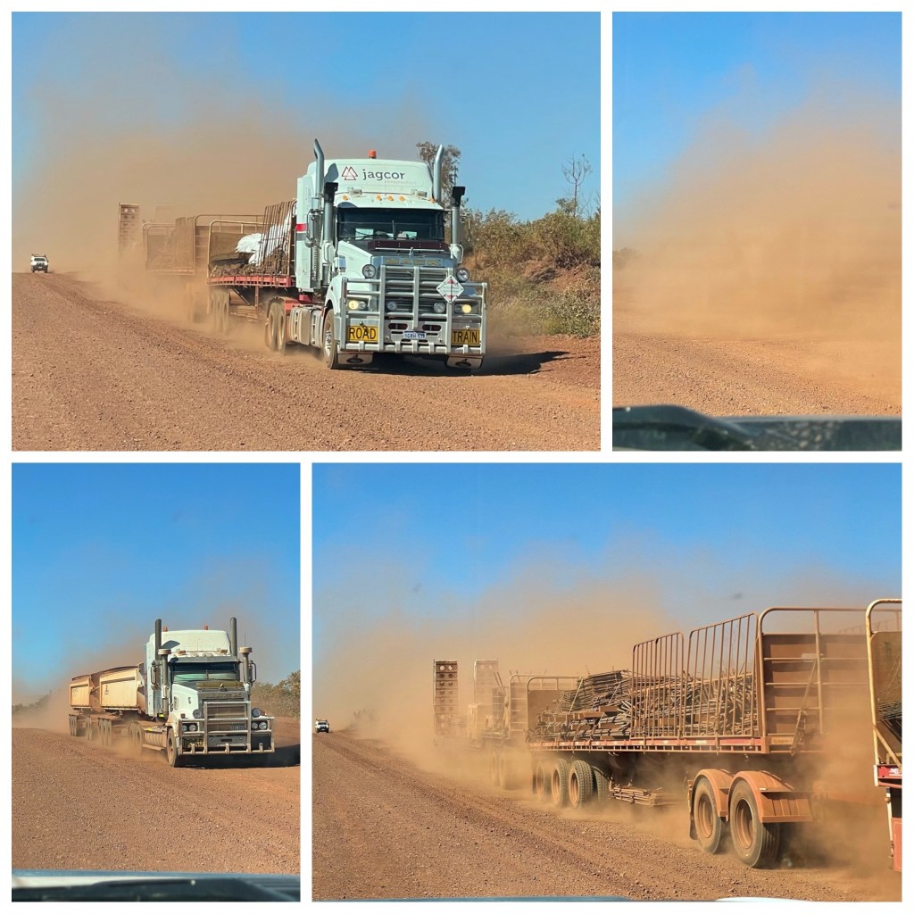
We are up and off early this morning as we have 300 plus kilometres of gravel road to reach Mt Augustus. We have debated several times whether we would visit Mt Augustus as it’s in a pretty isolated area and you really have to make the effort to visit. Anyway with the forecast wet at the coast (and not inland) it gives us the excuse to head this way. We are not disappointed, the drive through ever changing country, crossing dry creek and river beds, dry barren plains, gibber plains, lightly wooded areas, jump ups, and passing wonderful vistas has made the day enjoyable even if a little long. The road was slow, although a solid dry road it was rutted and slightly corrugated in places but we finally made Mt Augustus about 4pm. No sooner had we set up our camp here (staying two nights) than Road Closed signs were put out. That was a bit ominous and as we have no phone reception we can’t check weather reports. Not to worry the rains are suppose to be only along the coast with 3mm predicted here.

Oh Dear, We May Be Stuck

(P) Yesterday was a very scenic drive. Despite several weather checks we have potentially stuffed up the direction we have travelled! The John Williamson song “ It’s raining on the rock” sounds out true to us this morning But it’s the Wrong Damn “Rock”! They claim this rock is larger than its Central Australian cousin but to us it is invisible enshrouded in grey cloud!

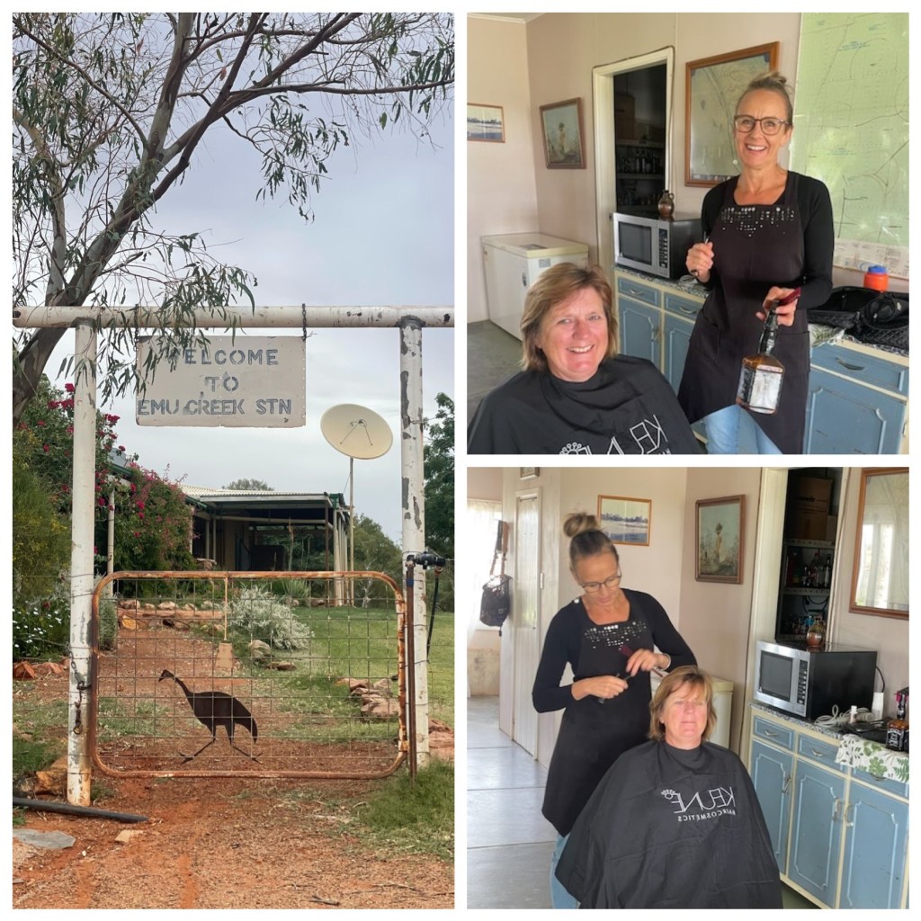
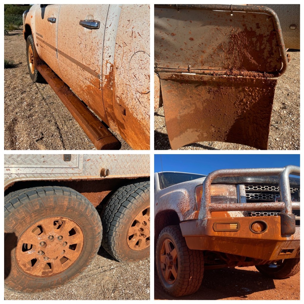
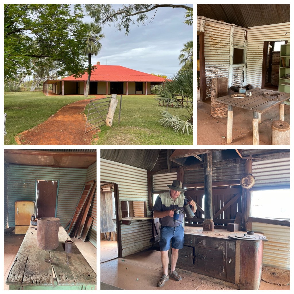
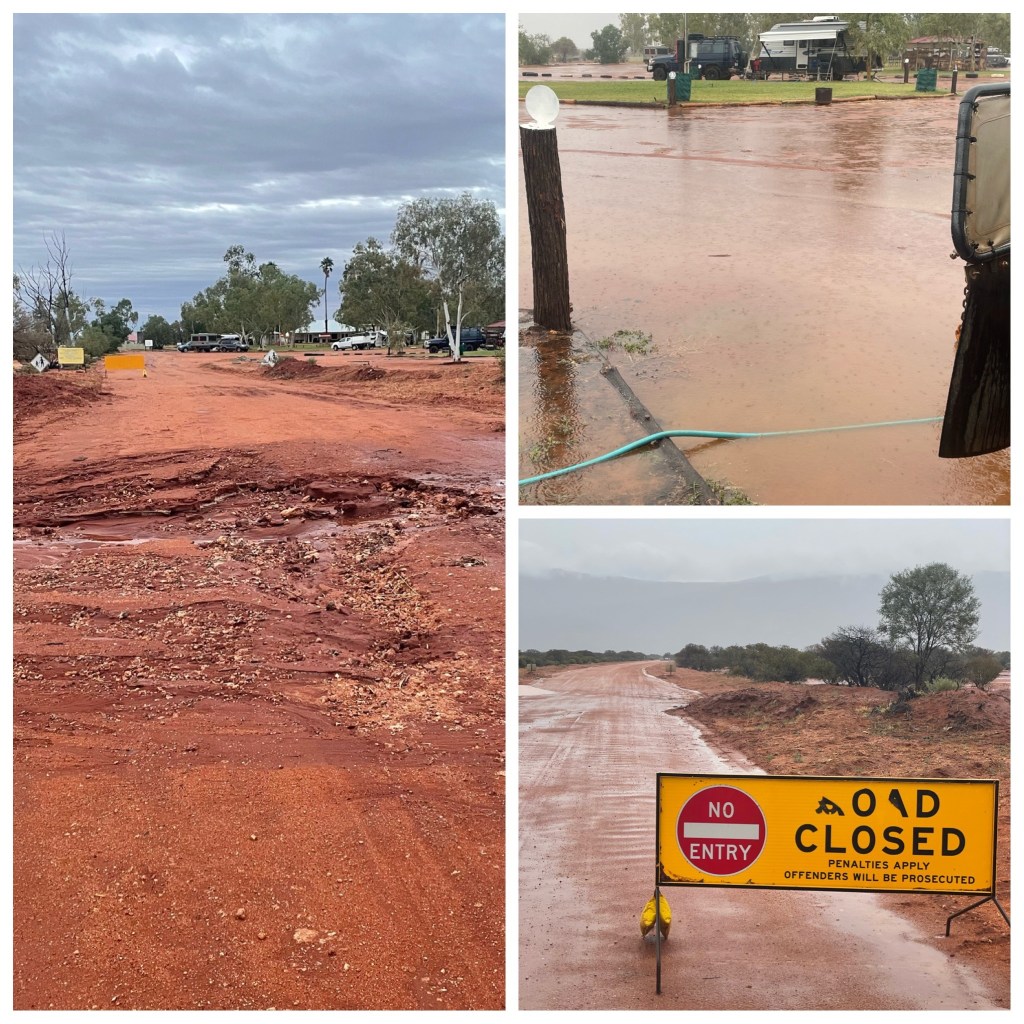
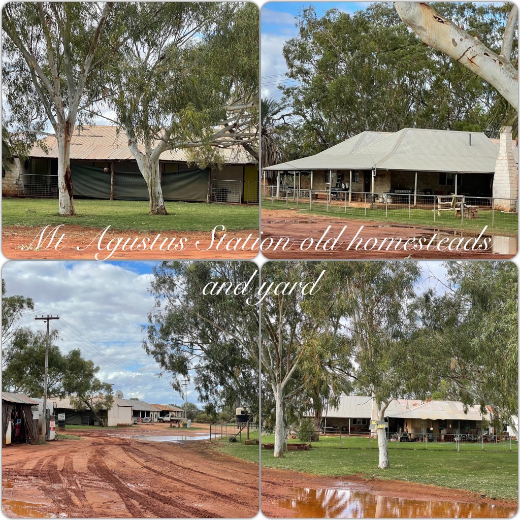
Judith was suggesting a few days in one spot may be good- perhaps Mt Augustus Station and it’s camp ground wasn’t exactly the resort location in her mind? We woke this morning to rain, wet roads and fresh sloppy cow dung around the camp, after all it is a working cattle station – the muster scheduled for Monday has been postponed due to the unscheduled wet.

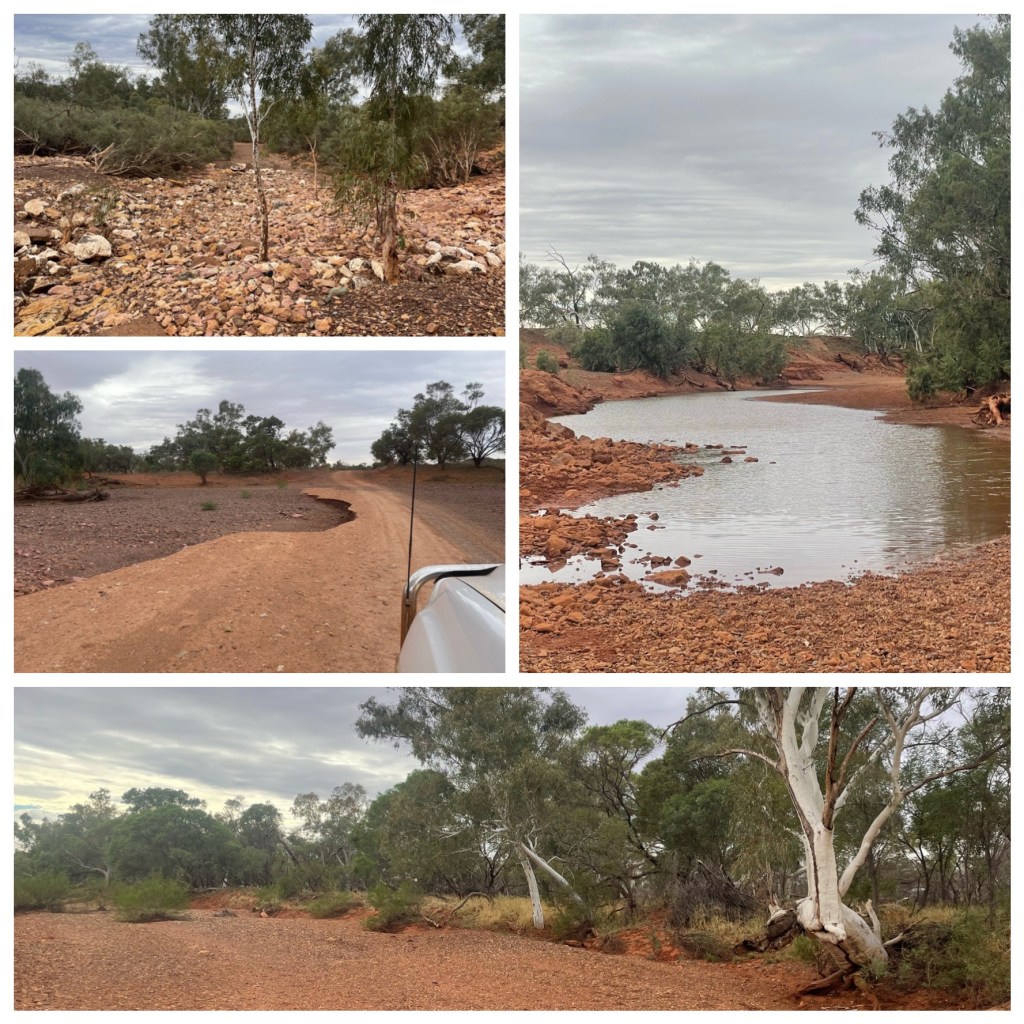
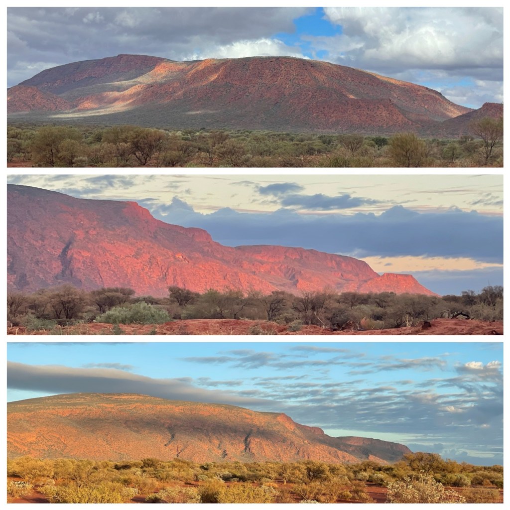
It’s wet, wet, wet and as the day progresses it gets wetter. Talking to staff here we had 10 mm overnight and another 30mm through the day. This makes for water lying everywhere. Heavy grey skies block our view and the road closed sign looks as though it will be in place for a few days a least. Philip is like a caged lion and this van is nowhere near big enough to keep him entertained if this rain keeps up for too long. Late morning after I have cooked apple muffins and cleaned a couple of drawers we don our Oilskin coats, Akubra hats and sandals, (it’s a great look) and paddle over to the office/shop to have a talk to staff there. She has decided to open the bar/lounge between 3 and 5 tonight so people can get out of their vans and spend some time together. As we walk back to van we get a small glimpse of the rock but it’s quickly covered in cloud again. More rain as the day wears on and Philip paces the van. Back to the bar at 3 and there are about 20 others there and we enjoy a great 2 hours finding out where others have been and are heading to. Road conditions have been compared and discussed and routes out of here debated. While we are enjoying everyone’s company the wether starts to lift and we are finally getting to see some of Mt Augustus.

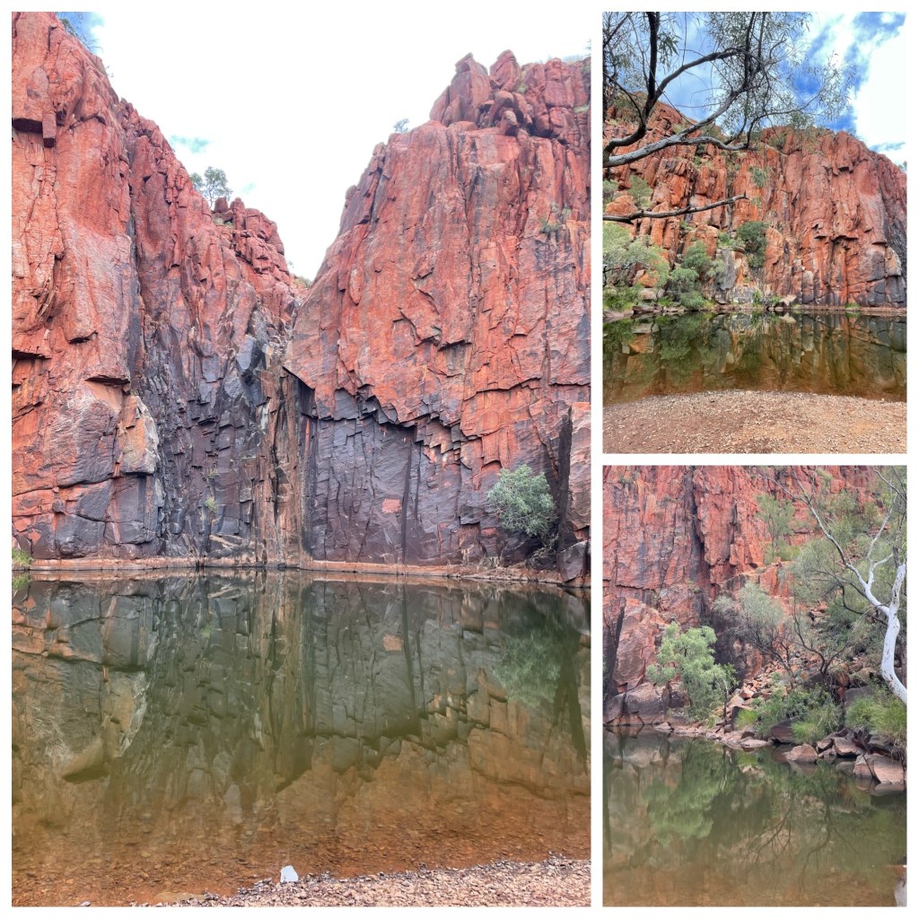
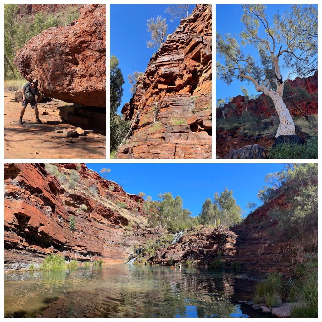
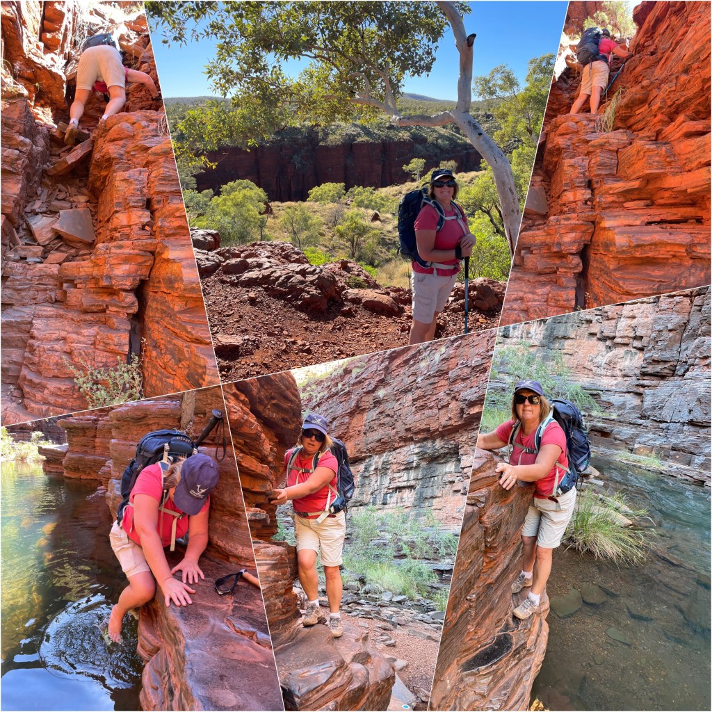
Overnight we get a few more showers but we wake to a semi clear morning and a sun spiking through. After breakfast we decide to walk from the campground to Gum Grove and Kotja gorge about a 12 k round trip. This could be all we see of Mt Augustus as the road around the rock is still closed and as soon as they open the road to Meekatharra we will be heading out.

The walk into the gorge was great. Only the last 2 kilometres was climbing over rocks and along a creek bed. We sat at the end of the gorge and had a drink and something to eat before filling our water bottles from the small creek that was running from under a large rock. Back to the van after 3.5 hours walk. We are heading back to the bar later armed with Philips IPad to show a couple of the others some places that we have been and they can show us where they’ve been.

River Red Gums Kotja Gorge

Thursday 10th June

(P) I clearly note Judith has Omitted the correct date on the above Kotja Gorge walk which we did on the 10th. Why one may ask? Most probably because she forgot my Birthday!!! I just laid low on comments until she realised. Sometime between 10 and 11 am, I was wished a happy Birthday ( after I had received other greetings from friends and family who knew our Satelite Phone number). Having published the above I won’t be admitting as to how many significant dates I may or may not have forgotten!

Friday 11th.

Today we woke to semi clear skies and a light breeze which is nicely drying out the roads. After a lovely hot breakfast of hash browns eggs and bacon, some household duties and a walk to the office, we found out that the Loop road around Mt Augustus is open and the road to Meekatharra will be open tomorrow morning. At this stage that is the only way out. While at the office the manager comes out and asked Philip when we needed to be back In Perth as if it was urgent she had talked to the Shire and gotten special permission for us to leave this afternoon. That’s pretty impressive that they would go to that trouble for us. We thanked her for “going the extra mile” and said we would allow a bit of time for roads to dry and leave tomorrow morning.

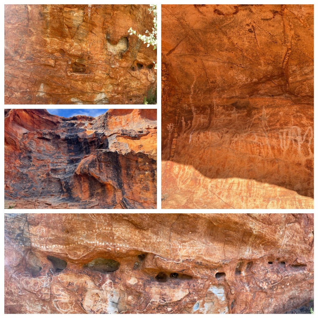
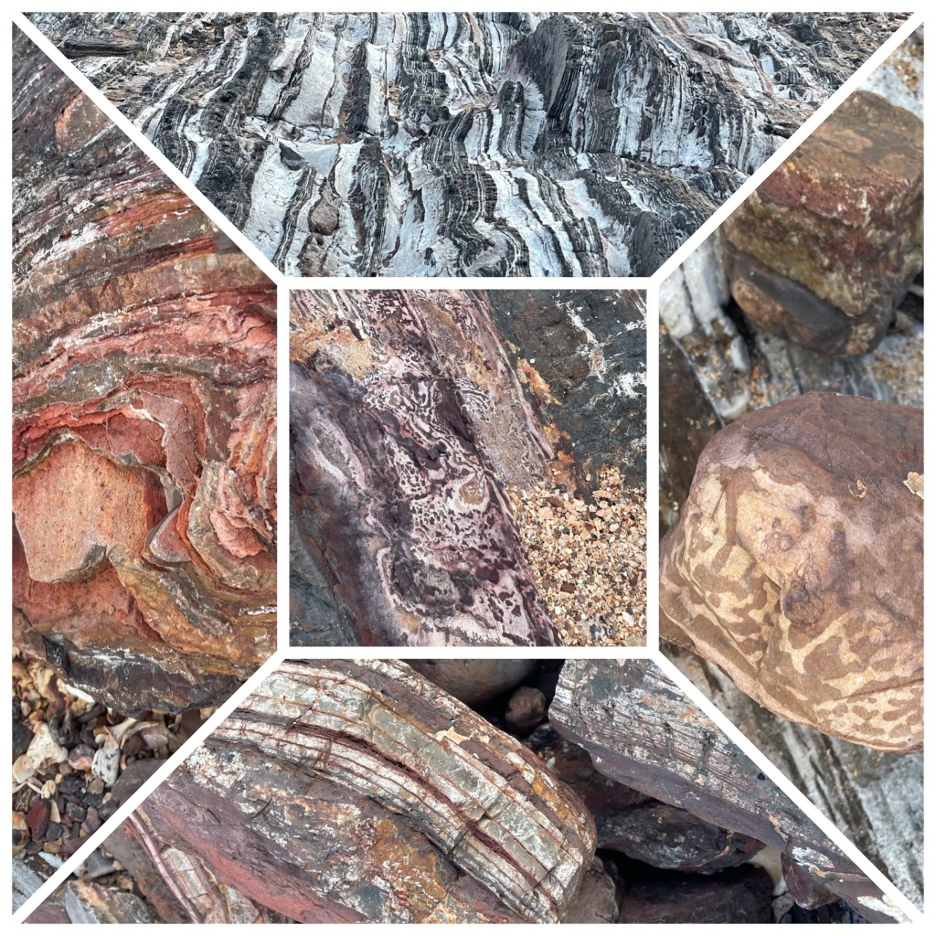
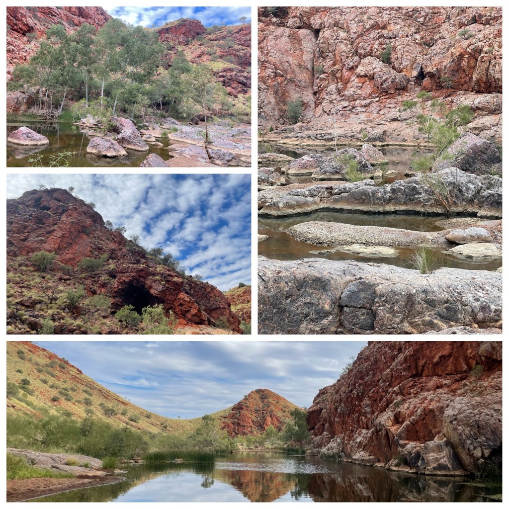
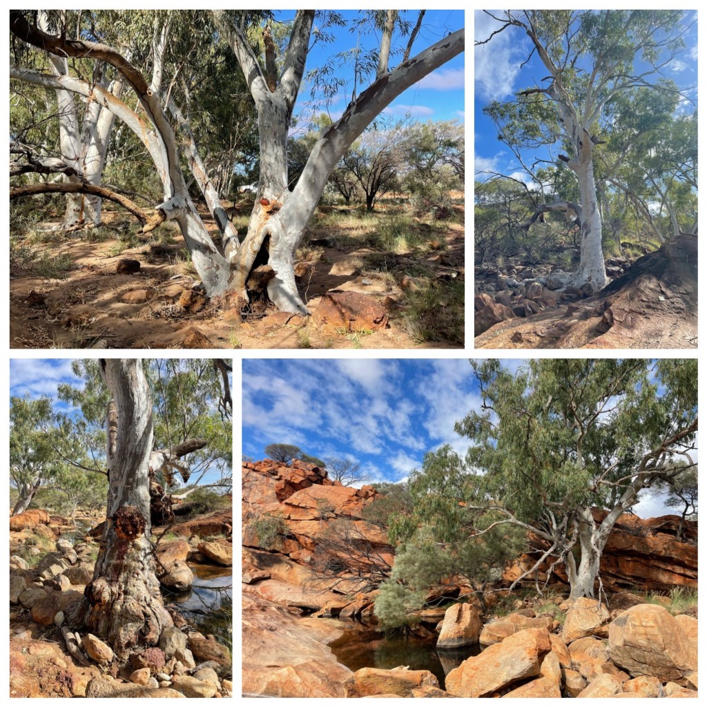
Back at the van we pack some lunch and our walking shoes, drinks and hats and take off around “The Rock”. First stop is Ooramboo to view some Aboriginal engravings and then to Edney Spring. These springs and creek bed are dotted with beautiful old River Red Gums. Shining white trunks show the tortured growing cycle they have had with burls wind bumps, broken limbs and twisted trunks. But they stand strong and solid in the rocky terrain and sandy creek beds. If only they could talk what a story they could tell. The engravings or Petroglyphs are open to your own interpretation and imagination. It’s hard to pick out anything distinctive.

Next stop is the Petroglyphs trail where more rock engravings are etched into the gorge wall.

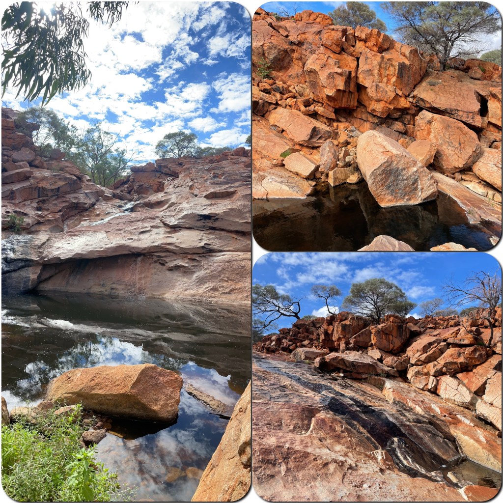
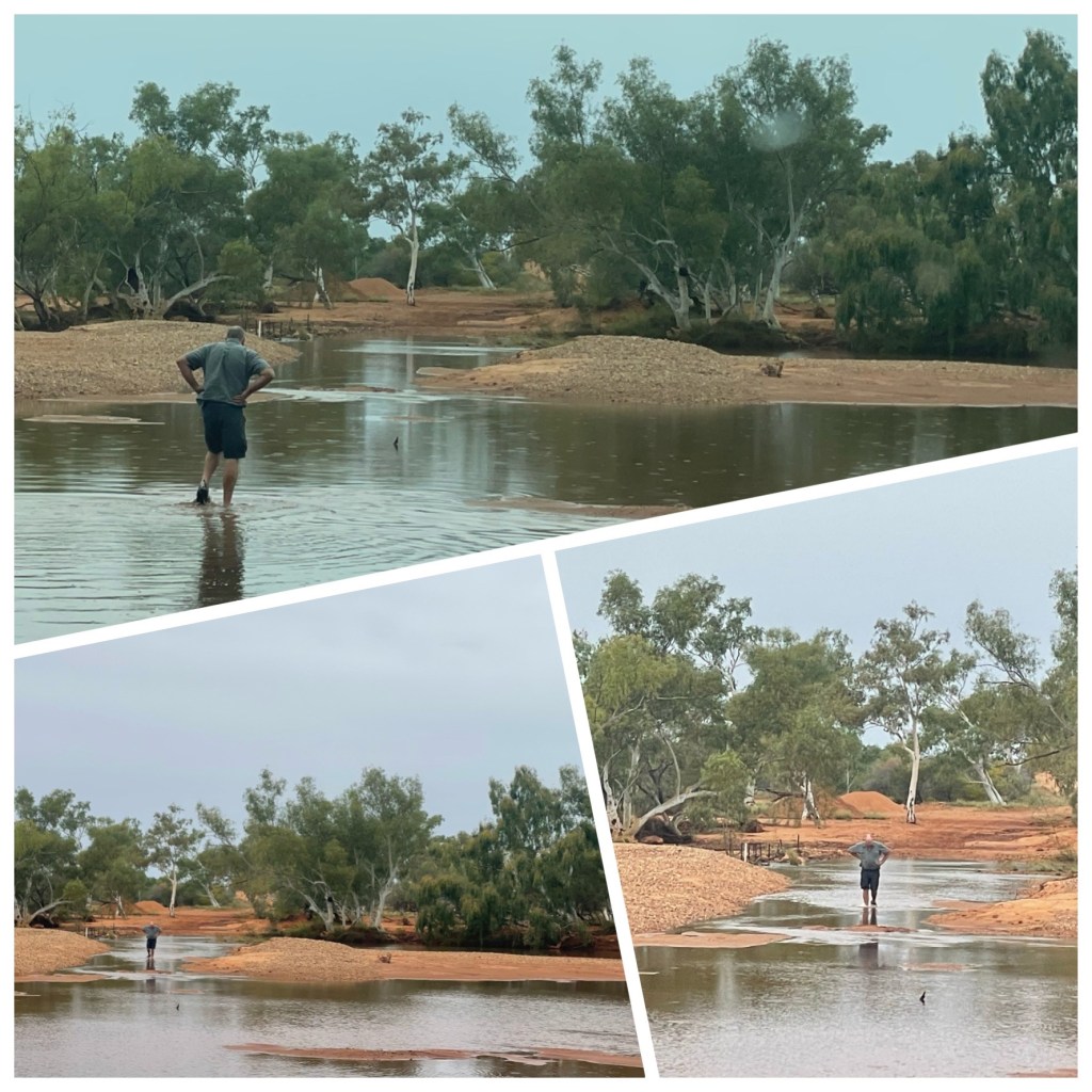
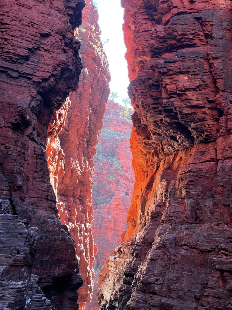
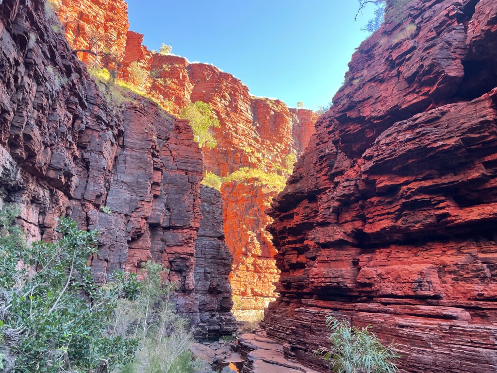
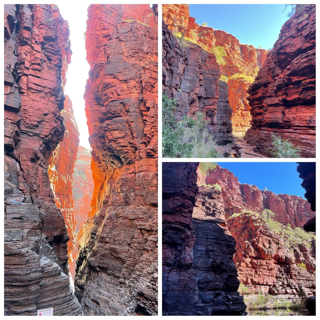
Flinstone Rock further around the rock is a lovely walk/clamber as we rock hop and climb along a creek bed. The trail leads to a large slab of rock that bridges a rocky stream. You can crawl under the rock to view more engravings. Climbing further past Flinstone Rock we followed the small stream up a rocky gorge, discovering rock pools and trickles of water flowing both over, under and around huge boulders. This is a lovely walk made even better because of the rain we have had causing the creeks to flow.

Emu Hill Lookout was our lunch stop with views over the Lyons River flood plains and back towards Mt Augustus. Our last stop on the loop was Cattle Pool. This is a permanent pool on the Lyons River.

In the end it has been a great experience being marooned on an outback station. Watching the water come and flood the campground and then slowly dissipate and experiencing Mt Augustus with water running down the rock faces is probably not what most tourists see.

Aboriginal Petroglyphs
Flinstone Rock Area
Mt Augustus
Uluru 2014. Mt Augustus 2021

Emu Creek Station

This station is a pastoral lease and cattle station which covers an area of 124988 hectares (308852 acres) and carries around 1500 head of cattle. That’s 1 beast every 83 hectares. The property was established in 1891 and initially covered an area of 202000 hectares. Sheep were first run at Emu Creek and an average of 20000 were shorn per annum in the early days.

We had decided to follow the Wool Wagon Pathway over the next few days so followed the road to Emu Creek Station. We turned off the main road and headed down the driveway until we came to the river crossing. Oh dear, this looks a bit iffy. Lots of water, boggy and sandy. Philip did a walk through of the river (P) whilst Judith became quiet, obviously anxiety was setting in! She of little trust! As if I would push the barriers a little for a bit of adventure). He decided that it wasn’t a possibility. So what to do now. There is a Shearing Shed on this property we would really like to see. Looking at the map there is an alternate road into the property it’s just 65 kilometres away, so off we went. This road in to the station was much better although there is still a creek crossing (Emu Creek) but it had no water.

Testing the River Depth

Current new caretakers Andrew and Denise, who have only been at the station for 6 weeks, are just finding their feet around the station. We met Denise as she checked us into the campground and chatted to her about the station and her work here. As we talked she mentioned in passing that she used to be a hairdresser on the east coast. Just a bit of a change of pace for her. We drove round to the campground and found our spot, on high ground. There has been lots of rain around here and the river has been high, therefore the riverside camps are still pretty soggy. It’s a lovely area around the campground though.

(P)After we set up we walked up to the Nyang Woolshed, apart from it being used for a bit of station storage the Shed and yards were just left as they were when the Station converted from wool to beef decades ago. Judith comments on the distinct Lanolin aroma still strong in the air as we enter the shed ( unfortunately I have lost my sense of smell over the last few years so just have to recall the distinct aroma Lanolin has). The 6 stand shearing machine equipment ( originally a 12 stand hand shear shed) all in place, narrow Combs, wool press, scales, Classers tables all there! Even the old gantry for loading the wool bales onto the wagons was mostly there. The old cooks kitchen all but complete and a wood fired oven mounted outdoors on a concrete slab an indication the cooking was done outdoors to keep the kitchen / dining room cooler ( or less unbearably hot in their climate. The station is in a state of slight disrepair, however the positive side to this is, it is a history time line if one makes the effort to wander around.

After checking out the Woolshed and shearer’s quarters and stock yards we wandered back into the homestead for another chat with Denise. Meanwhile I had been thinking, Denise is a hairdresser, wonder if she is doing any hair cutting. So I asked and no she wasn’t doing any but she had time in the morning and would love to give me a haircut. Awesome, I’m excited I need a cut badly.

Nyang Woolshed

Next morning we pack up lazily and at the appointed time we wander back to the homestead and there waiting in the dining room is a chair positioned ready for me. All Denise’s equipment spread out along the dresser but no Denise. We waited a while and she eventually appeared apologising that she had to finish her washing first. She is about as excited as me about doing her first haircut here at the station. (P) I was excited that I would not need Judith reminding me “I need a hair cut “ for a few more weeks!- the Emu Creek “Salon” included a hair wash in the station kitchen sink! I am sure the “station “Salon” experience will be special travel memory for Judith).

Emu Creek Hair Salon

We had a lovely 75 minutes as she cut, washed and blow dried my hair. We talked about all manner of topics from the property here, where we have been, what she would like to do around the homestead etc. Its amazing how a fresh haircut makes a person feel so much better.

While I had been enjoying this pampering Philip had been checking the weather for the next few days. It’s not looking good. Rain and storms on the coast for two days so we decide to head to Parabadoo (inland). It’s back up the blacktop to the Parabadoo turnoff where we stop for some lunch. Then on down the road. We pull into several 24 hour roadside stops hoping there might be a spot for the night but although they were nice spots with few campers already there, the way these campers had parked taking up way too much area stopped others camping as well. Some of these road warriors like their own space and prohibit others from camping around them. Its only early so we continue up the road and not far along we arrive at Cheela Plains Station Stay.

This place is on my long list of places to visit while in WA so in we go hoping we can get a spot for the night and yes there are still quite a few spots left even though they told us they were very busy with people heading away from the coast and the rain. As it’s only 3.30 and it’s still 27 degrees we decide to catch up on some washing knowing that it will be dry before bedtime.

Cheela Plains is a family owned and managed Arid country cattle station with a successful Station Stay facility which includes cabins, coach camping, caravan and tent areas, a restaurant and tours out to Beasley Gorge and surrounding areas. We enjoyed a lovely evening here and Philip caught an awesome sunrise from the top of the hill at the back of the campground. (P) Judith slept in whilst I wandered up a few hills catching a glimpse of the best part of any day. Here was a most spectacular, wild, “big sky” sunrise – I recalled the old saying “A red sky in the morning is a Shepherds warning” not thinking how true this saying would become! Whilst there I spotted the station ‘equipment retirement area’ and wandered for a look. Then came across some 50 huge mine trucks and loaders that have been retired. These are being prepared for shipping to India for recycling. A most enjoyable sunrise walk, Nature and Machinery – the perfect combination).

A Partial Car Wash at Cheela Plains
An Awesome Sunrise At Cheela Plains

Red Mud and Beachfront Camping

After leaving Port Hedland we headed down the blacktop making our way south. Not so sure it’s a good idea as the further south we go the cooler it gets. Still sitting around 25 degrees through the day so I don’t suppose I can complain too much. The next two days are just a matter of getting from point a to point b. We stopped in at the historic town of Cossack. This was quite a surprising little town. It was thriving in the 1870 and was once the areas first gold rush, pastoral and pearling port. Today it’s a living ghost town. After the move of the pearling industry to Broome, the end of the gold rush and the opening of the Point Sampson Jetty the town dissolved in 1910 and was abandoned by 1950. The bluestone buildings that remain have been restored and now welcome tourists to imagine what life would have been like in their heyday.

Tonight’s stop is 40 Mile Beach. Think white beach, 40 mile long, blue seas, boats and bronzed bodies. Nope that’s not quite what we found. It’s a lovely spot 40 mile from Karratha. Rocky foreshore, rock ledge dropping into the sea. Yes there are quite a few boats but not many bronzed bodies. People are fishing off the rocks but not catching much except for one lady who we spoke to. She admitted she didn’t know what she was doing. She was using what looked like a Kmart rod, bread and bacon for bait and had a bucket full of fish. No one else had any fish.

What amazes us about all these out of the way camp sites is that they all/or most have dump stations on site. Tasmania could learn a very good lesson from this.

Historic Cossack

Friday 4th June

Today we are headed for Giralia Station about 350 k away. There are quite a few caravans on the road today heading into a long weekend here in WA. I have decided that driving the blacktop is nowhere near as interesting as driving the gravel backroads. Set the cruise control at 100 and roll down the Highway until we meet a grey nomad (we aren’t considering ourselves that yet as we are not grey) travelling at 80 k and holding up all the traffic. The most exciting part of the day was when we pulled into Nanutarra Roadhouse to fill up with fuel. There is a line up for the diesel bowsers (2) about 8 vehicles in front of us and numerous behind us. Road trains parked in the lot and vehicles going everywhere. A bit disorganised. Vehicles must stay at bowsers until fuel is paid for. So the man in front of us fills his vehicle, saunters around his vehicle, grabs a couple of wipes and wipes down all around the filling cap, washes his windows hops in and out of his vehicle and then decides to wander over and pay for his fuel. 5 minutes later he emerges and moves his vehicle. No idea of how much he is holding up the stream of traffic now behind us.

We were much more efficient. While Philip refuelled I waited at the door to the shop for his thumbs up and paid promptly. Then Philip moved away and parked so we could use the facilities and buy an ice cream.

We turned onto Burkett Road, heading to Exmouth and then turned into Giralia Station stopping at the homestead to register. We are booked for the next two nights. Now for the drive out to the creek side/beachfront sites. It’s 35 kilometres on a bush track. The guy checking us in said they had had some rain so there were a few wet spots on the track. (He wasn’t kidding, lots of water and red mud). 35 k, 2 hours, mud, sand, creek crossings, washouts and dips. All made for a most exciting (nerve wracking) drive out to our campsite. We are now carrying quite a few extra kilos of red, thick mud coating every flat surface.

Giralia Station Camping Access Road
Oh Dear Lots of Mud

But after two hours we reach our site on the banks of the Creek at Sandalwood Landing on the edge of Gales Bay. 5 others camped at this spot but well spaced away from each other. We set up and wandered down to the creek to chat with the fishermen that have just returned empty handed. Apparently fishing is not very good here at the moment.

As night falls we have a wonderful sunset with the sky around us glowing red to orange and the milky way coming to life above us (P)as we enjoy a succulent Scotch Fillet steak and veggies all cooked over the hot coals – can’t beat a top camp spot on a beautiful evening with beautiful company and camp fire cooking) – the old abandoned gas bottle I found in the Goldfields that I cut down has been used many times- A great find! – cheaper than Gumtree!!!

Today we woke to a gorgeous sunrise with the promise of a great day ahead. Starting off the day with a cooked breakfast and a leisurely cuppa. We walked down to the mangroves to try to get out to the point but the tide is still too high so we picked up a few shells and wandered between the mangroves until we found a clearing where we could walk up to the road then back to the van.

Later we packed our lunch and drove to the beach campsite area to check it out. There are some lovely spots here today but it wouldn’t be quite so nice if it was windy. We strolled along the beach and paddled our way back to the truck where we enjoyed another tailgate lunch. Very nice watching and listening to the water as we enjoy our meal. (P) Sandwiches !!!! Well to be honest I had a fresh built “on the beach” Scotch Fillet steak sandwich and Judith had curried Tasmania Scallops with South Australian Prawns on fresh toast! I looked hard in the fridge but must have missed finding the salad today!

Great Shells
Beach Front
Sunset and Mangroves
Giralia Station Beachfront Camping

Once back at the van and when the tide is fully out we can walk out onto the sandbank at the mouth of the creek. Lots of hermit crabs, an octopus, crabs and shells. Its pretty nice being able to walk through the mangroves out into the water here. The mangroves are on sand / seashell base not mud as we normally find. (As the sun is about to reposition to give another part of our wonderful world a brand new day, I had best light the camp fire, put the Dutch oven full of vegetables on and grill some of our own home grown Tasmanian Lamb chops over the coals. (Pleased we have a good deep freeze with us- so far preventing us resorting to the emergency cans of Spam!)

On The Road To Somewhere!!!

29th May,

Last nights discussion was about our next destination as we start to head SOUTH. This morning we are awake early so pack up and get on the road. As we leave Tom Price, Philip takes the turn northward towards Port Hedland. “Hey this is the wrong way we are suppose to be heading south”.

I politely mention this to Philip and suggest he made the wrong turn. He replies by saying “didn’t you listen to the weather report at 5am”, no I’m still asleep then. Wet wet wet. Rain storms just where we had planned to go and on these dirt roads water and red mud don’t add up to an easy drive. (We later heard that the area had up to 40mm-60mm rain and roads will be impassable). So we are heading north to Port Hedland and we have got 5 nights there. We have had no trouble getting accommodation in parks although other travellers are saying that everything is booked out. So we have 350 k to travel today. (P) We have a shovel and winch but as far as I am concerned they are for “looks” not to use unless desperate! Given our back road travel preferences I would prefer to spontaneously plan than be locked into pre planned / pre paid itineraries that force one into making bad decisions!)

So what to do on the drive north today. Let’s count the Road Trains and see what they are carrying. Once we reach Port Hedland our tally is 215 4 trailer road trains plus 6 stopped at Auski Roadhouse, 350 kilometres and 4 hours travel time. Or one road train every 1.7 klm.

The trucks carried varied loads:-

Conveyor belting, over height

Huge steel beams

Mining Equipment

Cat 11 Dozer over width

Trucks carrying trucks

Gas trucks

Fuel trucks

Ore ball crusher bowls and crusher jaws

Front end Loader

2 x 8m wide dump trucks (over width)

New Dozer 4m wide at wheels

Ammonium Nitrate

And of course multiple loads of iron ore, about 25000 tonne of iron ore,

Not to mention the Lithium and other ores also being carted.

The “Truckies” are most polite and excellent to travel with, they will call us (on the radio) to overtake when they deem it safe and will have a short discussion at times also. At 60m long, up to 210 tonne with 98 wheels and travelling at 80-90 kph they are quite a length to overtake!

(P) As well as statistical engineer and mobile photographer, Judith spends her time knitting ( and “unknitting”) it seems to be 10 stitches forward / 5 back 10 forward etc. ! I guess that her style takes longer and saves buying as much wool!

Trucks and their Loads

Road Travel Discussions!

Judith has always managed the home budget! She made mention that “it seems cheaper for us to live on the road than when we are at home”. Like a fool I answered “yep we are not using any electricity etc while away” the immediate rely was “ it’s more like that there are no Ebay, Gumtree, or Face Book purchases while we are on the road”! Wow I walked into that one – I must be more careful with my replies in the future!

30th May to 3rd June

A few lazy days to recover ( I may have overdone things a bit the last few days), doing a few Maintenance jobs and enjoying the scenery of this heavy duty Industrial town.

24 hours a day we can hear the background sound of Trains, Road Trains, Tug Boats and many other HD industrial machines from our campsite some 3-4 klm from the action Zone.

(If Philip can hear the background noise then it’s loud because he’s hard of hearing most of the time)!

During our stay here we have done two tours. The first one organised by the Seafarers Mission. After a very informative audio visual presentation we hopped on a bus down to the harbour for a cruise on a workman’s launch around the harbour. This certainly made us see just how large the ships are and how small an area they have to spin the ships 360 degrees to get them heading back out to sea before they are pushed into their berth by 6 tugs. As we were touring past the ships we were also doing a grocery/gift delivery of pre-ordered items to some of the international crew. The orders are sent to the Seafarers mission who purchase the items, pack them individually, then deliver to the ships. The launch noses up the the side of the ship where a masked crewman lowers a rope which is attached to the bag of goods and then its hoisted up and over the railing. Items are delivered this way as COVID has stopped crew members from leaving their ship (some have been onboard for over 18 months!. We motor past all the ships currently berthed in the harbour. 19 ships can be berthed at one time with another two berths being built in the near further. All ships are bought in and turned to face back out to sea before being berthed.

Our next tour, the following day, was a Twighlight Industry Tour, departing from the visitors centre we drove out past the Rio Tinto solar Salt Farm which covers 9000 hectares and produces 3.2 million tonnes of industrial grade salt per year. The salt stacks are clearly visible from all over town. Our Owner/Driver guide was a wealth of information, he was constantly quoting figures and statistics as he drove us around. Past the Lithium Ore (Spodumene), copper ore, fuel storage farms, and the massive Iron Ore storage areas belonging to BHP, Fortescue Metals, Hancock Prospecting and Roy Hill operation. The enormity of these operations simply can’t be described.

A few statistics and photos may help with the story.

60 trains per day = 1 every 13 minutes

580+ kilometres of conveyor belting delivering ore from trains to sorting to stockpiles to ships

Roy Hill built 2 ship berths and infrastructure $10 billion including the mine and railway.

Most Machines are autonomous and operated from Perth

Shipping channel is 20 nautical miles

14.5 metres deep

Minimum of 4 tugs per ship (6 to berth in port)

64 ships anchorages

22 days sailing from China

538 million tonnes ore per year

5500 shipping movements per year

7.4 metre tidal range

280000 tonnes of ore per ship $60-70 million per ship

60% of ships going to China

Largest Tug fleet in the Southern Hemisphere

(P) In summary a mind blowing town with incredible statistics! The whole place is red with a tinge of Iron Ore dust, (probably not a good home for an OCD “Clean Freak” but) for a boy who appreciates the finer things in life (MACHINERY) Port Hedland has been another great visit. Complimented by the Mine visits that feed the Port. Tomorrow we depart on the road to – Somewhere.

Tug Pen and Sunset
Removal of Walkway

We enjoyed our tour of the harbour and told a few other campers about it. They all tried to book but were told that it wasn’t running at the moment. Next time we went down to the viewing platform the walkway to the pier was being removed. Guess that’s why the tour is not running. We were lucky enough to catch the last tour.

Return to Karijini

Thursday 27th May

We have been away from the van now for 3 nights and today we are heading back to Karijini before we reunite with our van in Tom Price.

Not sure whether I am keen to return Karijini to complete two more gorges or not. Weano Gorge will be okay but it’s Hancock Gorge that worries me. First up is Oxer Lookout, a great view over parts of Weano and Hancock. Then back to the start of Weano and down the steps to the gorge floor. Part of this gorge walk is closed due to a fatal and another serious incident earlier this year. I am pleased we are, not doing this section. (P) Judith sometimes struggles with stretching her sense of adventure!) We wander along the gorge floor Criss crossing the creek and admiring the swimming holes. Back up the hill to the car park where we stop for another tailgate lunch and a chat with the family parked next to us. This was a nice walk but not as good as some we have done.

View from Oxer Lookout

After lunch we are off to Hancock Gorge. This is what the brochures say about this walk “the exhilarating descent into Hancock Gorge has been described as a ‘journey to the centre of the earth’. After climbing down ladders you wander further into the gorge which narrows into a huge chamber with small rock pools and marbled walls.” Another brochure says “for the fit and adventurous. One of the most spectacular short walks…… you wade through cool pools, negotiate rock ledges and clamber through stony creeks. The gorge narrows and this is where the class 5 section comes into play. To continue you need a degree of flexibility and nerve…. straddle the gap between the gorge walls.

What stood out to me were a. Class 5, b. Wade through water, c. Straddle the gap.

Anyway off we went with nerves on high alert. The ladders were okay, not very long and easily managed, then a bit of rock hopping and climbing round ledges to get to the first pool. Steep walls on either side and cool water ahead. Well if others can do it then so can I. We wade through this pool only knee high then some more rock hopping. The gorge opens out into a large amphitheatre then turns and narrows to a chute . I can touch both sides and its slippery so take it cautiously. This then opens out to Kermits pool a deep water, blue pool. To get the best view the only way across is to swim. So swim we did. My heart is pounding and I’m shaking like a leaf but I have made it to the end and am rewarded with a fantastic view. Now I just have to make it back. We do make it back safely and are elated that we have managed this challenging walk/swim. (P) well make it back Judith did she swam like an Olympic champion! Forgetting my very limited “dog paddle” swimming ability I was left to save myself despite assurances we would swim together. Seriously Judith did excel with Hancock Gorge! There were many younger than her that turned back. She clearly has a reason to be proud! )

We have covered most of Karijini now and have to say it’s one of the best National Parks that we have seen. The walks are great, challenging, exhilarating, beautiful and awe inspiring but worth every shaken nerve, deep breath, sore knee and stiff joint.

Weano Gorge
The Ladders Hancock Gorge
Wading at Hancock
The Chute
Kermits Pool

Tom Price Mine Tour

Upon arriving in Tom Price we discovered that a mine tour was on offer. The Rio Tinto Iron Ore mine is located close to the edge of town. As with any tour we only get a snapshot of the operation but it was very interesting. Our coach driver was an old train driver whom I am guessing lost his job when Rio Tinto converted the majority of their loco fleet to autonomous operation. (They also have most of their large haul trucks operated autonomously) Hard to imagine over 28,000 tonne of ore per train on a continual stream of driverless trains! All of which are remotely controlled from the control rooms near Perth Airport some 1500 klm away! We were taken to a lookout over a rather large open cut mine where we could view the huge dump trucks and loaders operating. Following this we were driven thru active operations roads at the processing plant including viewing the terminus of a conveyor delivering ore from a mine some 30klm away. We were told this conveyor cost approx $1200000000 yep that’s 1.2 billion!!! For those interested and for me to remember in the future when this blog is converted to a coffee table book I will include the fact sheet on some part of Rio Tinto. Keep in mind there are several other operations including BHP, Hancock Prospecting, Fortescue that are digging massive holes in the ground so we can all enjoy metal based products.

What a place to vacation for a “boy who likes his toys (machinery)”!

Philip was listening to the rural report for the Pilbara early this morning and there was a report on the success they are having using the non contaminated groundwater from the mines to grow cattle fodder under centre pivot irrigation. A new enterprise for the area.

Aerial Shots Courtesy Google Earth

Bush to Beach and Back

For the last few days we have been off in the Roof Top Tent exploring some rougher roads. We left Tom Price And I had no idea where we were going! As usual Philip follows his “gut feeling” and we end up in a destination somewhere! “Pack enough food etc for 1-3 nights and see how we go” was his plan. We left the caravan in the park and headed north west up the Rio Tinto Rail Maintenance Access Road which follows along some of the rail lines heading to the coast. We hoped to see a train or two, which we did and quite a few more. These trains are very impressive from up close and although they are all the same we have to stop and watch each one pass. (P) depending on which line, approx 270 wagons and 6 locomotives. Each wagon with up to 150 tonne of iron ore! I know I have diesel and chunks of old machinery in my veins but anyone has to be impressed with these trains and for that matter the hugenessness (I know it’s spelt wrong but you will understand) of all but everything in the Pilbara!!!

The rail access road joins the main road to Mill Stream National Park so we stop in for a look at the old Homestead and points of interest as we drive past. Deep Reach on the Fortescue river is a lovely swimming spot, or would be if there wasn’t so much water from recent rains. It’s deep with lovely vegetation along the rivers edge.

The Homestead here was built in the 1920’s. It was once a thriving home on the edge of a large pastoral station. The shearer’s kitchen has been restored and is a great glimpse into the past.

Next stop on the other side of the park is Python Pool. On the road in we stop for lunch at a great outlook and have another lovely tailgate lunch enjoying the vista before us. Rolling hills, red rock cliffs, pyramid mountain and clear skies. (P) there is something special about driving thru “jump up” country ( as the pastoralists call it – hills that seem to jump up out of the surrounding flat ground) . The deep red colour of the soils and rocks in this area enhance the view more so). Python Pool is a gorgeous location with a lovely blue pool at the base of the escarpment. Shear red rock walls rise up from the water and almost enclose this lovely spot. From here we follow the road out to the NW Coastal Highway, driving through grazing country. It is so green here and contrasts beautifully with the red rock escarpments that litter the landscape. Pyramid Mountain looms before us as we near the Highway. Cattle graze on the lush grass and water lays along the road in low lying areas on Pyramid station. Truckies are heard talking on the radio about how green and lush it is. Some commenting they have never seen it like this. It certainly makes for lovely views.

Mill stream Homestead
Python Pool
Lunch time View

We find a lovely campsite at Clearville Beach and camp on the dunes that run along the bay. Great view of ocean tonight making a change from countryside. We walk along the beach and collect a few rocks as we go. The rocks here are lovely. Lots of different colours and patterns as shown by the photos below. A nice fire, (we need a fire a 27 degrees) to keep the bugs away and a lovely dinner fill our evening in.

Clearville Beach Camp
Rock formations along the beach
Sturt Desert Peas Blooming Everywhere

This morning before we leave the coast and head back inland. We drive round to Point Sampson and Dampier to check out some of the mining infrastructure and port facilities here. Couldn’t really see much but as usual Philip is intrigued with it all. A stop in at Karratha for a couple of things at the supermarket and a drive around the town area. Karratha is a nice little service town and caters well to all manner of interests here. Every second house in the area has a boat and/or caravan sitting out the front. Obviously fishing is good here. No lack of money in these towns.

Back on the road and again we are following a rail access route back inland. Plenty of trains today. All the drivers give a toot as they speed past. Trains today have 3 engines up front 133 wagons another 2 engines and another 133 wagons. A pretty impressive sight. We have no set destination today so are just following the roads where ever they lead. Our night is spent on the roadside grader turn around area on Hooley Station. Not another soul for miles and clear skies with a great view of the milky way. A small fire, a gentle breeze and an enjoyable dinner fill in the evening again.

Bush Hut, Windmill and Sheep Yard Fence
Passing Road Train
One of Many Trains

First stop this morning is Wittenoom. Originally an asbestos mining town but the area was declared a contaminated site. The site covers an area of 120,000 acres, the largest contaminated site in the Southern Hemisphere. Large signs at the entrances to the town say Do Not Stop. Nothing says you can’t drive through, so that’s just what we did. (As one would expect Philip to do). As we were driving through two vehicles came toward us one stopping to tell us to follow the road into the gorge where the mine site is visible. It is a gorgeous drive in crossing the riverbed numerous times before coming to a large pool. Gorgeous cliffs abound on both sides of the road. The sun is in just the right position and the cliffs almost glow. Climbing out at the road end asbestos tailings are clearly visible among the rocks on the ground and seams in the rock walls. It’s hard to believe that this is such a deadly material when you are working with it. In contrast to the asbestos the scenery is picturesque and the wildflowers are thriving.

P) Witternoom for a few years was a thriving town until the tragic effects of Asbestos was discovered. To date in excess of 30% of the miners in this town passed away from asbestos related disease! A horror story ! The town has been officially delisted and no longer shows on new maps. The most beautiful gorge drive could not erase the sadness of this place. Whilst there were beautiful potential camp sites here it wasn’t on the agenda – a bitter sweet part of the day), There are few homes left in the town site and only 3 or 4 people reside here now. What homes are left are falling into decay. It’s hard to imagine that just the other side of the range is Karijini National Park.

Continuing further we come to another part of the rail access route. Which takes us along the Roy Hill Road and although you don’t get views of the mine the trucks that bring ore out are numerous. 25 road trains in 40 kilometres. All the drivers are friendly and give a wave as they pass.

Tonight we are camped at another roadside stop ready to watch the super moon eclispse and we are not disappointed. We had clear views and the clouds stayed away.

Wittenoom Gorge
Wittenoom Gorge
Wittenoom Township

Spectacular Karijini

Leaving Marble Bar we headed down the Woodstock Road heading south. First stop was Flying Fox Lookout, looking over the Coongan River and Marble Bar. There are some mighty river systems up here and seeing water flowing in these rivers would be amazing. But not today there is just a small flow. The marble/jasper is quite noticeable along the river bed. Then off to Glen Herring Gorge (not even a sign on the roadside – just relying on good outback maps). You never know what you will find up these side roads or if there will be a turning spot for the truck and van. Luckily today there was, although tight and took a bit of manoeuvring. The road in wound up and over creek beds and hillocks past gum trees and spinifex covered hillsides. All set against a backdrop of deep red rock outcrops. Once into the car park we walked along the river bed and round the corner to a pretty impressive small gorge. Only about a half hour walk but well worth the effort. Back to the car park and we chatted to a couple camped there who gave us some tips on where to stay and what to see in the coming weeks. Our half hour detour off the main road turned into two hours. As we were leaving the gorge one flash of red stood out among the spinifex. Our first sighting of a Sturt Desert Pea.

Our overnight stop was at Albert Tognolini Lookout, a great lookout over Munjina Gorge. From the lookout we could watch the road trains labour their way up the hill and hear them rumble down the other side. From here we have just a quick run into Karijini National Park in the morning.

Glen Herring Gorge
Wonderful Wildflowers

We fuelled up at Auski Roadhouse. That was an experience. It was a busy road train stop, fuelling up, with both fuel and food, mine vehicles, tourists and an assortment of other vehicles and people. There was dust everywhere and on everything. Thick layers of deep red dust coating fuel bowsers, trucks, paths and anything else that had a flat surface it could cling to.

We could set up in the Overflow Campground at Karijini from 10 am so we aimed for that so we could get a walk in during the afternoon. Our first walk was Dales Gorge, starting with 290 odd steps down to Fortescue Falls. Just “gorge”ous and a lovely spot to swim later. From Fortescue to Ferny pool, then back past Fortescue Falls to begin the walk along the floor of the gorge. 3 kilometres weaving our way along the path, over streams, over rocks, through water and beneath shady trees. A lovely walk and great views of the cliffs overhead. Unfortunately Circular Pool at the end of the track was closed due to a rockfall so it was back up the steep rocky steps to the overview of Circular Pool. Then back along the rim to the car park. A great view and now we are ready for a swim so it’s back down the 290 plus steps to Fortescue Falls and into the water. How refreshing and such a stunning place to swim. You could sit on the ledge under the waterfall and have a private spa or just float and enjoy the 360 degree view of majestic nature. Back to camp and a drink and relax before dinner.

It’s interesting watching people as they arrive with their vans in tow. This park area would hold about 40 vans, it only has about 12 here but some have to drive round and round until they think they have just the right spot. Then they jostle backward and forwards, until they have the van in the perfect position. Unhook the vehicle, lower the legs, put out the awning, set up tables and chairs, hang out washing and have a drink. Makes for interesting watching.

Ferny Pool
Dales Gorge
Dales Gorge and Fortescue Falls

Friday 21st we are up early and on the road out to Joffre Falls but the track is closed so we continue on to Knox Gorge. I’m not sure about doing this walk. A class 5 track. Brochure says a high level of fitness and agility required. Steep sections with vertical drops are common. Mmmmm not sure about this! But reassured by an all too familiar Philip saying “she be rite we can always turn back” statement, we start off on the trail and for the first 20 metres it’s fine. Then it’s down hill or should I say down a cliff face. Fantastic views are all that keep me going. One step at a time. About 500 metres almost straight down but we finally reach the bottom and marvel at the route we have just taken. Then as we wander along the floor of the gorge each turn brings more spectacular vistas. Criss crossing the creek, rock hopping and standing in awe of this place we reach a pool where the gorge turns 90 degrees. Hmmmm this is gunna be interesting. The corner is steep with few foot holds and fewer handholds but Philip makes it round while I chose to sit this part out. There is no one else around at the moment. It’s a peaceful and awe inspiring place to rest for a few minutes. Philip finally returns! (P) I had a reason to “finally “ return. There was an adventure tour group that was in at the end of the gorge having coffee and fresh ginger nut cookies – soft and filled with some gooey sweet stuff. It would have been rude of me to rush back and not enjoy their company ( and cookies) and disturb Judith’s “quiet” time alone!) after watching another group shimmy round the corner Philip convinces me to give it a try because the best is yet to come. Nerves kicked in but after a few deep breathes and encouragement from Philip and others I made it round and continued to the end of the gorge. (P) I note there is no mention of Philip removing his shoes, sacrificing life and limb by wading thru the stream acting as a human prop to prevent Judith from doing a backflip into the water ( all because her legs and arms were too short to grab the minimal foot and rock holds)! One lady did tell me what a wonderful husband I was! (I accepted the compliment graciously) This is a truly spectacular place.

I must mention how awesome the Pilbra has been so far, spectacular vistas, huge machinery, monster trucks, historic mines, relics, buildings and massive mines, friendly people and some of the most spectacular gorges we have visited anywhere! It certainly isn’t promoted like the Kimberley but it is an awesome area to spend time, much more time than we initially planned to.

Wildlife Along the Way
Intrepid Walker
Knox Gorge

My husband, always thinking, is wandering along thinking out loud. “I wonder how magnetic this rock is around here. Yep he had to try to find out so stuck his phone close to the ground and boy is it magnetic as you can see from the photos. Next thought is could I weld this rock because of its iron content. Maybe try another time.

Philips Experiment

Marble Bar

Tuesday 18th

Today is home duties day. (P) A mans work is never done!!! That means washing clothes and floors, cleaning bathroom and all those other yuck jobs that need to be done to keep our house in order. But first up, before it heats up, we are off for a walk around town. We checked out some of the heritage sites, called into the general store for some eggs (P) and fresh baked apple strudel for dessert this evening), then visited the information centre. The lady there was very helpful and full of information and sent us on our way with maps and details of where to visit.

After lunch we took off to see Marble Bar which is about 5 k out of town. This is the phenomena that gave the town its name. Unfortunately it’s not actually marble but Jasper. The rock doesn’t look much until it’s wet and then the colours really show out.

Marble Bar

Driving a bit further you never know what you will come across. About 40 k out of town is the remains of a Secret WW11 airbase. Two very distinct runways are almost all that can be seen. With markers showing where ammunition dumps, fuel dumps, accommodation sites etc were.

This base was set on Corunna Station and had air crew quarters, kitchen mess, canteen, post office and store. The runways, one 2300 m long the other 1650 m long and both 50 m wide are just cleared strips in the spinifex landscape. Long range B24 Liberator bombers thundered down these strips. Heavily loaded with bombs they were on their way to Japanese bases in a Java, Borneo, Singapore and other targets in South East Asia. About 300 people lived at Corunna Downs, most in four man tents. They were tormented with heat, flies, snakes and scorpions. The temperature could reach 50 degrees and the brackish artesian water was so hot that it only cooled enough to shower after 9 pm.

Well with no other vehicles in site and two very clear runways, what would you expect a rev head husband to do. Well that’s exactly what he did. 170 kph drag down the runway and we still didn’t take off! We have good brakes though. (P) I was responsible and did a runway check first as a good pilot always does! They say “you can never take the youth out of a man” no matter what age. That was fun!!! I also flew my drone as the airfield can be better appreciated with the aerial photos. Not sure what they used for weed control 75 odd years ago but the area is still relatively denuded of vegetation even after all this time!

Driving back to the main road we followed a road train. Philip got on the radio and asked him some questions. We now know that he is called a Super Train, 4 trailers, 98 wheels and tyres, 60 metres long, 550 HP and 3 rear drive axles, total weight 205 tonnes, has a payload of 139 tonnes, he does a 410 k round trip to Port Hedland and does two round trips per day. Pretty impressive numbers really.

Back at the van we enjoyed a lovely drink with our neighbours comparing notes on where we had been and what we had seen during our travels, comparing roads and campsites along the way.

The Road into Corunna Downs
The Super Train
Signs at Entrance to Marble Bar